2023-10-05

Verweildauer der Parteien in deutschen Regierungen

Wie lange war eine bestimmte Partei in Deutschland an einer Bundes- oder Landesregierung beteiligt? Diese Frage möchte ich hier mit Grafiken beantworten.

Stichtag der Statistiken ist der 5. Oktober 2023. Ich zähle alle Bundes- und Landesregierungen der Bundesrepublik Deutschland. In den westdeutschen Bundesländern zähle ich auch Regierungen, die bereits vor Gründung der Bundesrepublik demokratisch gewählt wurden. Da Berlin vor der Wiedervereinigung kein Bundesland war, fange ich dort erst 1991 an zu zählen.

Bundesregierung: 66% CDU, 65% FDP, 49% SPD, 16% DP, 12% Grüne, 5% GB/BHE

In den 74 Jahren seit Gründung der Bundesrepublik war die CDU (meistens zusammen mit der CSU) 49 Jahre lang an Regierungen beteiligt, die FDP 48 Jahre lang, die SPD 36½ Jahre lang, die Deutsche Partei 12 Jahre lang, die Grünen (bzw. Bündnis 90/Grüne) fast 9 Jahre lang, der Gesamtdeutsche Bund/Bund der Heimatvertriebenen und Entrechteten 4 Jahre lang.


Hamburg: 78% SPD, 39% FDP

Bremen: 100% SPD, 37% FDP

Bayern: 91% CSU, 13% FDP

Hessen: 63% SPD, 38% CDU

Schl.-Holstein: 69% CDU, 39% SPD

Niedersachsen: 66% SPD, 55% CDU

NRW: 63% SPD, 38% FDP

Rheinl.-Pfalz: 66% FDP, 58% CDU

Ba.-Wü.: 87% CDU, 41% FDP

Saarland: 76% CDU, 46% SPD

Sachsen: 100% CDU, 42% SPD

Meck.-Pomm.: 94% SPD, 70% CDU

Brandenburg: 92% SPD, 30% Linke/PDS

Sachsen-Anh.: 77% SPD, 67% CDU

Thüringen: 73% CDU, 57% SPD

Berlin: 94% SPD, 50% Linke/PDS
(seit der Wiedervereinigung)


Nach Parteien sortiert:

CDU/CSU

  • Sachsen 100%, d.h. seit 1990 gab es keine Landesregierung ohne CDU-Beteiligung
  • Bayern 91%: Die CSU war 70 Jahre lang an der Regierung, 7 Jahre in der Opposition
  • Baden-Württemberg 87%: Die CDU war 62 von 71½ Jahren an der Regierung
  • ...
  • Brandenburg 28%: 9 Jahre mit CDU-Regierung, 24 Jahre ohne
  • Bremen 26%: Innerhalb von 77 Jahren war die CDU ein Viertel der Zeit an der Regierung
  • Hamburg 17%: Nur 13½ von 77 Jahren mit CDU-Regierung

SPD

  • Bremen 100%
  • Berlin 94%
  • Mecklenburg-Vorpommern 94%
  • ...
  • Schleswig-Holstein 39%
  • Baden-Württemberg 32%
  • Bayern 10%

FDP

  • Rheinland-Pfalz 66%
  • Bund 65%
  • Baden-Württemberg 41%
  • ...
  • Mecklenburg-Vorpommern 12%
  • Brandenburg 12%
  • Berlin 0%

Grüne

  • Sachsen-Anhalt 28%
  • Thüringen 27%
  • Schleswig-Holstein 26%
  • ...
  • Sachsen 12%
  • Saarland 4%
  • Bayern und Mecklenburg-Vorpommern 0%

Linke (inkl. PDS)

  • Berlin 50%
  • Brandenburg 30%
  • Mecklenburg-Vorpommern 30%
  • Thüringen 27%
  • andere Länder 0%

Sonstige

  • Niedersachsen 31% (GH/BHE, DZP, DP, KPD)
  • Hamburg 23% (KPD, DP, STATT, PRO)
  • Schleswig-Holstein 22% (GB/BHE, SSW, DP)
  • Bund 22% (DP und GB/BHE)
  • Bayern 21% (GH/BHE, FW, BP, WAV)
  • Nordrhein-Westfalen 19% (DZP, KPD)
  • Baden-Württemberg 17% (GH/BHE)
  • Hessen 16% (GH/BHE)
  • Bremen 7% (GH/BHE und KPD)
  • Rheinland-Pfalz 5% (KPD)
  • neuere Bundesländer <1% (SVP)

2023-05-05

Deutsche Bundesländer – vor 1000 Jahren

Die 16 Bundesländer, die Deutschland heute hat, sind das Ergebnis einer Jahrhunderte langen Entwicklung. Vor tausend Jahren sahen die Grenzen noch ganz anders aus.

In diesem Gedankenexperiment zeige ich Deutschland in den heutigen Grenzen mit den heutigen Landkreisen und kreisfreien Städten (die auch historisch gewachsen sind; zuletzt durch Gebietsreformen in manchen Bundesländern), aber den ungefähren Grenzen der Herrschaftsgebiete des Jahres 1023. Die Einwohnerzahlen habe ich 2023 von Wikipedia abgeschrieben.

Deutschlandkarte mit den Grenzen in rot

Statt der heutigen Bundesländer habe ich in der obigen Karte 10 Großregionen eingezeichnet, und zwar unter Berücksichtigung der heutigen Kreisgrenzen:

  1. Sachsen, ehemaliges Stammesherzogtum mit der Hauptstadt Lüneburg, das 1023 von Bernhard II. angeführt wurde. Heute hat diese Großregion 20.901.933 Einwohner auf 85.649 km². Sie erstreckt sich vom Rhein bis zur Elbe und vom Siegerland bis nach Holstein.
  2. Franken, beziehungsweise die Stammesherzogtümer Ost- und Westfranken mit den Hauptstädten Würzburg und Worms. Heute hat diese Großregion 16.460.094 Einwohner auf 63.887 km². Sie erstreckt über vom heutigen Franken bis zum Hunsrück und von Kassel bis kurz vor Stuttgart.
  3. Lothringen, beziehungsweise die Stammesherzogtümer Ober- und Niederlothringen, die zu diesem Zeitpunkt bereits geschrumpft waren. 1023 wurde Oberlothringen von Friedrich III., Niederlothringen von Gottfried II. angeführt. Weite Teile des damaligen Lothringen gehören heute zu Frankreich und den Benelux-Staaten. Der deutsche Teil der Großregion – von der Saar bis zum Niederrhein – hat heute 12.006.945 Einwohner auf 24.282 km².
  4. Schwaben, auch Herzogtum Alamannien genannt, mit der Hauptstadt Straßburg im Elsass, das 1023 von Ernst II. angeführt wurde. Heute hat diese Großregion 8.771.155 Einwohner auf 34.280 km². Sie umfasst bayerisch Schwaben und die südliche Hälfte Baden-Württembergs.
  5. Bayern, genauer gesagt das Stammesherzogtum Baiern mit dem Nordgau, wurde 1023 von Heinrich V. angeführt. Heute hat diese Großregion 8.296.199 Einwohner auf 41.805 km². Sie erstreckt sich im Wesentlichen über die bayerischen Bezirke Oberbayern, Niederbayern und Oberpfalz.
  6. Der Bund der Lutizen war kein germanisches Stammesherzogtum, sondern ein loser Bund „heidnischer“ slawischer Stämme, die sich im Aufstand von 983 von der Herrschaft der christlichen Sachsen befreit hatten. Heute hat diese Großregion 7.964.845 Einwohner auf 47.826 km². Sie erstreckt sich von der Ostseeküste bis Berlin und kurz vor Magdeburg.
  7. Sorben und andere slawische Stämme standen unter der Herrschaft sächsischer Markgrafen. 1023 lebten nur wenige Deutsche in diesem Gebiet. Heute hat diese Großregion 6.070.442 Einwohner auf 38.724 km². Sie erstreckt sich von der Neiße bis zur Saale.
  8. Thüringen („TH“ auf der Karte) war 1023 kein Herzogtum, sondern unterstand mehreren Adligen. Graf Wilhelm III. von Weimar galt als wichtigster Herrscher der Gegend. Heute hat diese Großregion 1.383.204 Einwohner auf 10.785 km², ist also kleiner als das Bundesland Thüringen.
  9. Zu Dänemark („DK“ auf der Karte) unter König Knut dem Großen gehörten 1023 auch Teile von Schleswig. In dem Teil der Region, der heute zu Deutschland gehört, leben 738.525 Einwohner auf 6.431 km².
  10. Ostfriesland („OF“ auf der Karte) war ein kleiner Teil der Frieslande, die 1023 entweder frei waren oder Graf Dietrich III. von Holland unterstanden. Der Teil der Region, der heute zu Deutschland gehört, hat 643.822 Einwohner auf 3.859 km².

2021-06-04

[en] Population Growth in Luxembourg

Between 1960 and 2020, the population of the Grand Duchy of Luxembourg has doubled. The neighbouring countries have not seen such drastic increases:


  • +99% in Luxembourg
  • +26% in Belgium
  • +20% in the German state of Rhineland-Palatinate
  • +18% in the French Moselle department
  • –7% in the German state of Saarland


The following maps show the population changes of the decades since the 1960s, for each of the Grand Duchy's 12 cantons:
1960s

1970s

1980s

1990s

2000s

2010s


Source: Wikipedia, in particular the population figures on the French Wikipedia pages on the individual cantons.

2021-04-14

[de] Regionen gleicher Größe für Deutschland

Eine Spielerei mit Verwaltungsgrenzen in Deutschland

Die 401 Kreise und kreisfreien Städte habe ich in Großräume zusammengefasst. Jeder Großraum ist etwas gleich groß, nämlich ± 6000 km. Im Mittelpunkt steht eine Stadt oder ein Ballungsgebiet.

Anschließend habe ich die 59 Großräume zu 12 Regionen gleicher Einwohnerstärke (±7 Millionen) zusammengefasst. Auf die Grenzen der Bundesländer habe ich dabei keine Rücksicht genommen.

die 12 Regionen
(blau: Grenzen der Großräume)

Grundlage aller hier gezeigten Karten ist übrigens der Wikipedia-Artikel Verwaltungsgliederung Deutschlands.

Hier das Ergebnis (sortiert nach Bevölkerungsdichte):


Der Niederrhein beginnt bei Bonn und fließt in die Niederlande.

Die niederrheinische Region ist identisch mit dem bevölkerungsreichsten Großraum, dem Großraum Niederrhein mit der Hauptstadt Düsseldorf. Dort leben 6,2 Mio. Menschen auf 6.558 km². Die Region umfasst die Städte Bonn, Düsseldorf, Köln, Krefeld, Leverkusen, Mönchengladbach, Remscheid, Solingen, Wuppertal sowie die Kreise Kleve, Mettmann, Neuss, Rhein-Erft-Kreis, Rhein-Sieg-Kreis, Rheinisch-Bergischer Kreis und Viersen.

Diese Region umfasst das Ruhrgebiet und das Mûnsterland in NRW.

Die Ruhr-Region mit der Hauptstadt Essen hat 7,2 Mio. Einwohner auf 11.448 km². Sie besteht aus zwei Großräumen:

  1. Ruhr (5,5 Mio. Einwohner) mit den Städten Bochum, Bottrop, Dortmund, Duisburg, Essen, Gelsenkirchen, Hagen, Hamm, Herne, Mülheim, Oberhausen und den Kreisen Ennepe-Ruhr-Kreis, Märkischer Kreis, Recklinghausen, Unna und Wesel.
  2. Münster (1,6 Mio. Einwohner) mit der Stadt Münster und den Kreisen Borken, Coesfeld, Steinfurt, Warendorf.

Nicht ganz Baden-Württemberg gehört zu dieser Region.

Die badisch-württembergische Region mit der Hauptstadt Stuttgart hat 7,2 Mio. Einwohner auf 19.708 km². Sie besteht aus drei Großräumen:

  1. Stuttgart-Karlsruhe (4 Mio. E.) mit den Städten Karlsruhe, Pforzheim und Stuttgart sowie den Landkreisen Böblingen, Calw, Enzkreis, Esslingen, Göppingen, Karlsruhe, Ludwigsburg, Rems-Murr-Kreis.
  2. Freiburg (1,8 Mio. E.) mit den Städten Baden-Baden und Freiburg und den Landkreisen Breisgau-Hochschwarzwald, Emmendingen, Lörrach, Ortenau, Rastatt, Waldshut.
  3. Tübingen (1,4 Mio. E.) mit den Landkreisen Freudenstadt, Reutlingen, Rottweil, Schwarzwald-Baar, Tübingen, Tuttlingen und Zollernalb und dem ehemaligen Landkreis Ehingen.

Nur im Westen entspricht die Grenze dieser Region der des Landes Hessen.

Die hessische Region mit der Hauptstadt Darmstadt hat 6,6 Mio. Einwohner auf 26.291 km². Sie besteht aus vier Großräumen:

  1. Rhein-Main (3,7 Mio. E.) mit den Städten Darmstadt, Frankfurt am Main, Offenbach und Wiesbaden, Hochtaunuskreis, Main-Kinzig-Kreis, Main-Taunus-Kreis, Rheingau-Taunus-Kreis, Wetteraukreis sowie den Landkreisen Darmstadt-Dieburg, Groß-Gerau und Offenbach.
  2. Mittelhessen (1,2 Mio. E.) mit den Landkreisen Gießen, Lahn-Dill, Limburg-Weilburg, Vogelsberg und Waldeck-Frankenberg.
  3. Spessart-Odenwald (1 Mio. E.) mit den Städten Aschaffenburg und Schweinfurt sowie den Landkreisen Aschaffenburg, Bad Kissingen, Haßberge, Main-Spessart, Miltenberg, Odenwaldkreis und Schweinfurt.
  4. Fulda (0,8 Mio. E.) mit der Stadt Eisenach und den Landkreisen Fulda und Hersfeld-Rotenburg, dem Schwalm-Eder-Kreis, dem Unstrut-Hainich-Kreis und dem Wartburgkreis.

Zur Zeit Napoleons existierte die Cisrhenanische Republik westlich des Rheins.

Die cisrhenanische Region mit der Hauptstadt Mainz hat 7,8 Mio. Einwohner auf 29.104 km². Sie besteht aus fünf Großräumen:

  1. Rhein-Neckar (2,4 Mio. E.) mit den Städten Frankenthal, Heidelberg, Landau, Ludwigshafen, Mannheim, Neustadt, Speyer und Worms sowie den Landkreisen Bad Dürkheim, Bergstraße, Germersheim, Neckar-Odenwald, Rhein-Neckar, Rhein-Pfalz und Südliche Weinstraße.
  2. Eifel (1,6 Mio. E.) mit der Städteregion Aachen und den Kreisen Ahrweiler, Düren, Euskirchen, Heinsberg, Neuwied und Vulkaneifel.
  3. Saar-Pfalz (1,5 Mio. E.) mit den Städten Kaiserslautern, Pirmasens und Zweibrücken, dem Regionalverband Saarbrücken, dem Donnersberg- und Saarpfalz-Kreis sowie den Landkreisen Kaiserslautern, Kusel, Merzig-Wadern, Neunkirchen, Saarlouis, Sankt Wendel und Südwestpfalz.
  4. Mittelrhein (1,3 Mio. E.) mit den Städten Koblenz und Mainz sowie den Landkreisen Altenkirchen, Alzey-Worms, Bad Kreuznach, Mainz-Bingen, Rhein-Hunsrück, Rhein-Lahn und Westerwald.
  5. Mosel (0,8 Mio. E.) mit der Stadt Trier, dem Eifelkreis Bitburg-Prüm und den Landkreisen Bernkastel-Wittlich, Birkenfeld, Cochem-Zell, Mayen-Koblenz.

Diese Region umfasst die deutschen Alpen und das Alpenvorland.

Die Region Oberland mit der Hauptstadt München hat 7,2 Mio. E. auf 30.001 km². Sie besteht aus fünf Großräumen:

  1. München (2,9 Mio. E.) mit der Stadt München und den Landkreisen Dachau, Ebersberg, Erding, Freising, Fürstenfeldbruck, Landsberg, München, Starnberg.
  2. Augsburg-Ulm (1,5 Mio. E.) mit den Städten Augsburg und Ulm sowie den Landkreisen Aichach-Friedberg, Augsburg, Dillingen, Donau-Ries, Günzburg, Neu-Ulm und dem größten Teil des Alb-Donau-Kreises.
  3. Bodensee-Oberschwaben (1,2 Mio. E.) mit den Landkreisen Biberach, Bodenseekreis, Konstanz, Lindau, Ravensburg und Sigmaringen.
  4. Chiemgau-Berchtesgaden (0,8 Mio. E.) mit der Stadt Rosenheim und den Landkreisen Bad Tölz-Wolfratshausen, Berchtesgadener Land, Miesbach, Rosenheim, Traunstein.
  5. Allgäu (0,8 Mio. E.) mit den Städten Kaufbeuren, Kempten, Memmingen und den Landkreisen Garmisch-Partenkirchen, Oberallgäu, Ostallgäu, Unterallgäu, Weilheim-Schongau.
Zum 1813 aufgelösten Königreich Westphalen gehörten
u.a. Hannover, Magdeburg, Kassel und Paderborn.

Die westphälische Region mit der Hauptstadt Hannover hat 7 Mio. Einwohner auf 35.308 km². Sie besteht aus sechs Großräumen:

  1. Hannover-Braunschweig (2,2 Mio. E.) mit den Städten Braunschweig und Salzgitter, der Region Hannover und den Landkreisen Goslar, Hildesheim, Peine und Wolfenbüttel.
  2. Siegen-Arnsberg (1,5 Mio. E.) mit dem Hochsauerlandkreis, dem Oberbergischen Kreis, der Hälfte des Kreises Soest sowie den Kreisen Olpe, Siegen-Wittgenstein und Unna.
  3. Kassel-Göttingen (1,1 Mio. E.) mit der Stadt Kassel und den Landkreisen Eichsfeld, Göttingen, Kassel, Northeim und dem Werra-Meißner-Kreis.
  4. Paderborn (1 Mio. E.) mit den Landkreisen Hameln-Pyrmont, Holzminden, Höxter, Paderborn und Schaumburg sowie Teilen der Kreise Nienburg und Soest.
  5. Magdeburg (0,7 Mio. E.) mit der Stadt Magdeburg und den Landkreisen Börde, Jerichower Land, Salzland.
  6. Harz (0,5 Mio. E.) mit den Landkreisen Harz, Kyffhäuser, Mansfeld-Südharz und Nordhausen.

Die Grenzen der Regionen orientieren sich, wie gesagt,
weder an aktuellen noch an historischen Ländern.

Die niedersächsische Region mit der Hauptstadt Bremen hat 6,7 Mio. Einwohner auf 35.842 km². Sie besteht aus sechs Großräumen:

  1. Ostwestfalen (2,1 Mio. E.) mit den Städten Bielefeld und Osnabrück sowie den Kreisen Gütersloh, Herford, Lippe, Minden-Lübbecke und Osnabrück.
  2. Bremen-Oldenburg (1,6 Mio. E.) mit den Städten Bremen, Bremerhaven, Delmenhorst, Oldenburg und den Landkreisen Cuxhaven, Oldenburg, Osterholz, Verden, Wesermarsch.
  3. Ostfriesland (0,9 Mio. E.) mit den Städten Emden und Wilhelmshaven, den Landkreisen Ammerland, Aurich, Friesland, Leer, Wittmund und Teilen der Landkreise Cloppenburg und Emsland.
  4. Ems-Hase (0,9 Mio. E.) mit den Landkreisen Cloppenburg (Hälfte), Diepholz, Emsland (größter Teil), Grafschaft Bentheim, Nienburg und Vechta.
  5. Wolfsburg-Celle (0,7 Mio. E.) mit der Stadt Wolfsburg und den Landkreisen Celle, Gifhorn, Helmstedt und Uelzen.
  6. Oste (0,5 Mio. E.) mit dem Heidekreis, den Landkreisen Rotenburg und Stade sowie der Samtgemeinde Amelinghausen.

Vor 1815 war Sachsen deutlich größer als heute.

Die sächsische Region mit der Hauptstadt Dresden hat 6,8 Mio. Einwohner auf 37.506 km². Sie besteht aus sechs Großräumen:

  1. Leipzig-Halle (1,6 Mio. E.) mit den Städten Halle und Leipzig, dem Burgenlandkreis, dem Saalekreis, dem Landkreis Leipzig und dem Landkreis Nordsachsen.
  2. Dresden (1,3 Mio. E.) mit der Stadt Dresden und den Landkreisen Bautzen, Meißen, Sächsische Schweiz-Osterzgebirge.
  3. Chemnitz-Zwickau (1,3 Mio. E.) mit der Stadt Chemnitz und den Landkreisen Altenburger Land, Erzgebirgskreis, Mittelsachsen, Zwickau.
  4. Thüringer Städtekette (1,2 Mio. E.) mit den Städten Erfurt, Gera, Jena, Weimar und den Landkreisen Gotha, Greiz, Saale-Holzland-Kreis, Sömmerda, Weimarer Land.
  5. Fichtelgebirge (0,7 Mio. E.) mit der Stadt Hof und den Landkreisen Hof, Kronach, Kulmbach, Lichtenfels, Saale-Orla-Kreis, Tirschenreuth, Vogtlandkreis, Wunsiedel.
  6. Fränkisch Thüringen (0,7 Mio. E.) mit den Städten Coburg und Suhl sowie den Landkreisen Hildburghausen, Ilm-Kreis, Rhön-Grabfeld, Saalfeld-Rudolstadt, Schmalkalden-Meiningen und Sonneberg.

Außerhalb der Bundeshauptstadt ist diese Region extrem dünn besiedelt.

Die märkische Region mit der Hauptstadt Potsdam hat 7 Mio. Einwohner auf 41.691 km². Sie besteht aus sieben Großräumen:

  1. Berlin (4,8 Mio. E.) mit den Städten Berlin und Potsdam und angrenzenden Teilen der Landkreise Barnim, Dahme-Spreewald, Havelland, Märkisch Oderland, Oberhavel, Oder-Spree, Potsdam-Mittelmark, Teltow-Fläming.
  2. Cottbus-Frankfurt (0,7 Mio. E.) mit den Städten Cottbus und Frankfurt/Oder sowie den Landkreisen Görlitz, Oder-Spree und Spree-Neiße.
  3. Anhalt-Mark (0,4 Mio. E.) mit der Stadt Dessau-Roßlau, dem Landkreis Anhalt-Bitterfeld und Teilen der Landkreise Potsdam-Mittelmark, Teltow-Fläming und Wittenberg.
  4. Spreewald (0,3 Mio. E.) mit den Landkreisen Elbe-Elster und Oberspreewald-Lausitz sowie Teilen der Landkreise Dahme-Spreewald und Wittenberg.
  5. Havel (0,3 Mio. E.) mit der Stadt Brandenburg, den Ämtern Beetzsee und Wusterwitz, Teilen des Landkreises Havelland sowie den Landkreisen Prignitz und Ostprignitz-Ruppin.
  6. Altmark (0,3 Mio. E.) mit dem Altmarkkreis Salzwedel, den Landkreisen Lüchow-Dannenberg und Stendal, dem Amt Neuhaus und der Samtgemeinde Dahlenburg.
  7. Oder-Havel (0,2 Mio. E) mit Teilen der Landkreise Barnim, Märkisch Oderland, Oberhavel und Uckermark.

Zu dieser Region gehört sowohl württembergisch Franken als auch die Oberpfalz.

Die fränkisch-bayerische Region mit der Hauptstadt Nürnberg hat 7 Mio. Einwohner auf 42.252 km². Sie besteht aus sieben Großräumen:

  1. Nürnberg (1,9 Mio. E.) mit den Städten Bamberg, Bayreuth, Erlangen, Fürth, Nürnberg, Schwabach und den Landkreisen Bamberg, Bayreuth, Erlangen-Höchstadt, Forchheim, Fürth, Nürnberger Land, Roth.
  2. Heilbronn (1,2 Mio. E.) mit der Stadt Heilbronn und den Landkreisen Heidenheim, Heilbronn, Hohenlohe, Ostalb, Schwäbisch Hall.
  3. Ingolstadt (0,9 Mio. E.) mit den Städten Ingolstadt und Landshut sowie den Landkreisen Eichstätt, Kelheim, Landshut, Neuburg-Schrobenhausen, Pfaffenhofen und Weißenburg-Gunzenhausen.
  4. Oberpfalz (0,9 Mio. E.) mit den Städten Amberg, Regensburg und Weiden sowie den Landkreisen Amberg-Sulzbach, Neumarkt, Neustadt an der Waldnaab, Regensburg, Schwandorf.
  5. Würzburg (0,8 Mio. E.) mit den Städten Ansbach und Würzburg sowie den Landkreisen Ansbach, Kitzingen, Main-Tauber, Neustadt-Bad Windsheim und Würzburg.
  6. Straubing (0,7 Mio. E.) mit der Stadt Straubing und den Landkreisen Altötting, Deggendorf, Dingolfing-Landau, Mühldorf Rottal-Inn und Straubing-Bogen.
  7. Passau (0,5 Mio. E.) mit der Stadt Passau und den Landkreisen Cham, Freyung-Grafenau, Passau, Regen.

Auch ein Teil der Nordseeküste befindet sich in dieser Region.

Die Ostsee-Region mit der Hauptstadt Schwerin hat 6,9 Mio. Einwohner auf 43.290 km². Sie besteht aus sieben Großräumen:

  1. Hamburg (3,3 Mio. E.) mit den Städten Hamburg und Lübeck, dem Landkreis Harburg, dem größten Teil des Landkreises Lüneburg sowie den Kreisen Herzogtum Lauenburg, Pinneberg und Stormarn.
  2. Holstein (1,2 Mio. E.) mit den Städten Kiel und Neumünster und den Kreisen Ostholstein, Plön, Rendsburg-Eckernförde und Segeberg.
  3. Schleswig (0,7 Mio. E) mit der Stadt Flensburg und den Kreisen Dithmarschen, Nordfriesland, Schleswig-Flensburg und Steinburg.
  4. Rostock-Rügen (0,6 Mio. E.) mit der Stadt Rostock und den Landkreisen Rostock und Vorpommern-Rügen.
  5. Schwerin (0,5 Mio. E.) mit der Stadt Schwerin und den Landkreisen Ludwigslust-Parchim und Nordwestmecklenburg.
  6. Uecker (0,3 Mio. E.) mit dem Landkreis Vorpommern-Greifswald und der nördlichen Hälfte des Landkreises Uckermark.
  7. Mecklenburgische Seenplatte (0,2 Mio. E.) mit dem gleichnamigen größten Landkreis Deutschlands.


2019-08-12

[en] Europe's High Population Density Zones

Have you heard of 
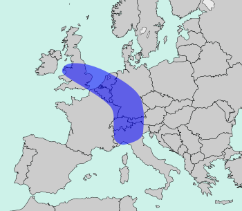
The Blue Banana? According to Wikipedia, it is “a discontinuous corridor of urbanisation” that spans from Wales to Northern Italy and passes through densely populated areas of the Benelux countries and Germany:

source: https://commons.wikimedia.org/wiki/File:Blue_Banana.svg

I wanted to examine the Blue Banana in more detail. So I found this map that shows the population density of Europe's NUTS 3 regions:

source: https://www.reddit.com/r/europe/comments/7tcv83/population_density_in_europe/

Based on this map, I have identified contiguous high population density zones in Europe – regions entirely composed of blue and black areas on the map above. And here they are, Europe's largest high-density zones:

High Density Zones of Central Europe

1. The Rhine+ Zone 

This is the central core zone of the Blue Banana. It is one of the the largest multi-national agglomerations in the world. The zone roughly follows the course of the Rhine river from Lake Constance to the Randstad. However, the 24 most populous cities of Europe are not included in the Rhine+ Zone.

Area: 161,381 km² (62,310 sq mi)
Population: 72.6 million
Cities: Brussels, Cologne, Amsterdam, Frankfurt, Rotterdam
Countries:
  • all of Liechtenstein
  • 96% of the population and 90% of the area of the Netherlands, a few northeastern regions excluded 
    • excluding the COROP regions Zeeuws Vlaanderen, Zuidwest-Friesland, Noord-Drenthe, Oost-Groningen, Delfzijl en omgeving
  • 83% of the population and 56% of the area of Belgium, in Brussels, almost all of Flanders, and parts of Wallonia 
    • excluding the Flemish arrondissement of Veurne
    • including the Walloon arrondissements of Charleroi, Liège, Mons, Mouscron, Soignies, Tournai, Waremme
  • 52% of the population and 24% of the area of Switzerland, mostly in the German-speaking north 
    • including the cantons of Aargau, Appenzell Ausserrhoden, Basel Landschaft, Basel Stadt, Luzern, Sankt Gallen, Schaffhausen, Solothurn, Thurgau, Zug, Zürich
  • 43% of the population and 21% of the area of Germany, mostly in the west and south-west 
    • Baden-Württemberg without BC; FDS, KÜN, MOS, SHA, RV, RW, SIG, TBB, UL, WT
    • Hessen without Odenwaldkreis, Vogelsbergkreis, Regierungsbezirk Kassel
    • Niedersachsen including only H, HI, HM, BS, PE, SHG, SZ and the city of Osnabrück
    • Nordrhein/Westfalen without Kreis Euskirchen, Hochsauerlandkreis, Kreis Höxter
    • Rheinland-Pfalz including only AK, AZ, DÜW, FT, GER, KO, LU, MYK, MZ, NR, NW, SP, WO, WW
  • 9% of the population and 3% of the area of France, at the Belgian and German borders
    • including the départements Bas-Rhin, Haut-Rhin, Nord, Pas-de-Calais, Territoire-de-Belfort
  • 3% of the population and 0.9% of the area of Austria, in the far west of the country 
    • including Bezirke Dornbirn and Feldkirch, parts of Bezirk Bregenz
     

2. The English-Welsh Zone

This is the northwestern or British part of the Blue Banana. Britain being an island, it is not really contiguous to nearby France and Belgium.

Area: 74,344 km² (28,704 sq mi)
Population: 48.1 million
Cities: London, Birmingham, Liverpool, Manchester, Sheffield
Country: United Kingdom 
  • 83% of the population and 53% of the area of England, mostly in the west and south
    • East without Breckland, North/South/West Norfolk
    • East Midlands without Lincolnshire 
    • Greater London
    • North-West without Cumbria
    • West Midlands without Herefordshire and Shropshire
    • South-East
    • South-West including only Bath and North East Somerset, Bristol, Gloucestershire, North Somerset, South Gloucestershire, Swindon
    • Yorkshire and the Humber without East and North Yorkshire
  • 61% of the population and 20% of the area of Wales, mostly in the far south and north-east
    • including Blaenau Bridgend, Gwent, Caerphilly, Cardiff, Flintshire, Monmouthshire, Neath Port Talbot, Newport, Swansea, Torfaen, Valley of Glamorgan, Wrexham

3. The North Italian Zone

The southern (mostly Italian) part of the Blue Banana is almost contiguous. It actually consists of four subzones that are separated by only a few kilometers:
  • The Milan–Venice Zone with a population of 14.3 million on 32,583 km² (12,580 sq mi)
  • The Bologna–Florence Zone with a population of 4.2 million on 17,158 km² (6,625 sq mi)
  • The Genoa–Nice–Monaco Zone with a population of 2.7 million on 9,717 km² (3,752 sq mi)
  • The Turin Zone with a population of 2.4 million on 7,740 km² (2,988 sq mi)
Area: 67,198 km² (25,945 sq mi)
Population: 23.6 million
Cities: Milano, Torino, Genova, Bologna, Firenze

Countries:  
  • all of Monaco
  • 37% of the population and 21% of the area of Italy, all in the north, of course
    • Emilia-Romagna including BO, MO, RA, RE
    • all of Liguria
    • Lombardia without MN, SO
    • Piemonte including BI, NO, TO
    • Toscana including FI, LU, PO, PT
    • Veneto without BL, RO
  • 1.6% of the population and 0.7% of the area of France, at the Italian border
    • département Alpes-Maritimes only 


1–3 The Blue Banana combined

If you combine the English-Welsh Zone, the Rhine+ Zone and the North Italian zone, you get a non-contiguous area with the following features.

Area: 303,849 km² (117,317 sq mi)
Population: 145 million

Cities: London, Milan, Brussels, Birmingham, Cologne
Countries: Austria, Belgium, France, Germany, Italy, Liechtenstein, Monaco, the Netherlands, San Marino, Switzerland, United Kingdom

4. Istanbul

Area: 25,556 km² (9,867 sq mi), 14% of which is in Europe, 86% in Asia
Population: 21 million, 46% of which is in Europe, 54% in Asia

Cities: İstanbul, Bursa, Adapazarı, İzmit, Gebze
Country: Turkey (provinces Bursa, İstanbul, Kocaeli, Sakarya, Yalova)

The zone covers 26% of the population and 3% of the area of Turkey.

5. Valencia

Area: 21,617 km² (8,346 sq mi)
Population: 5.5 million

Cities: València/Valencia, Palma, Alacant/Alicante, Elx/Elche, Castelló(n) de la Plana

Country: Spain (provinces of Alicante, Valencia and the Balearic Islands).

6. Rome–Naples

Area: 16,403 km² (6,333 sq mi)
Population: 10 million

Cities: Roma, Napoli, Salerno, Latina, Giugliano

Countries: Italy (provinces Caserta, Latina, Napoli, Roma, Salerno), Vatican City

7. Sicilian Zone

Area: 15,597 km² (6,022 sq mi)
Population: 3.7 million

Cities: Palermo, Catania, Messina, Siracusa

Country: Italy (provinces of Catania, Messina, Palermo, Ragusa, Siracusa)

8. Upper Silesian Zone

Area: 14,711 km² (5,680 sq mi)
Population: 5.2 million

Cities: Katowice, Ostrava, Sosnowiec, Gliwice, Bytom
Countries: 
  • In Poland, it contains the Upper Silesian Voivodeship (województwo śląskie) with the exception of the Częstochowa area. It makes up 11% of the population and 3% of the area of Poland.
  • In Czechia, it contains the Moravian-Silesian Region (moravskoslezský kraj), which has 11% of the population and 7% of the area of the Czech Republic.

9. Apulian Zone

Area: 12,533 km² (4,839 sq mi)
Population: 3.4 million

Cities: Bari, Taranto, Andria, Lecce, Barletta

Country: Italy (Metroplitan City of Bari, provinces of Barletta-Andria-Trani, Brindisi, Lecce, Taranto)

10. Paris

Area: 12,012 km² (4,638 sq mi)
Population: 12 million

Cities: Paris, Boulogne-Billancourt, Saint-Denis, Argenteuil, Montreuil

Country: France (région Île-de-France) .

11. Geneva

Area: 10,355 km² (3,998 sq mi)
Population: 2.6 million

Cities: Genève, Annecy, Lausanne, La Chaux-de-Fonds, Fribourg

Countries: Switzerland (cantons de  Fribourg, Genève, Neuchâtel, Vaud), France (département Haute-Savoie).

12. Moscow 

Area: 9,648 km² (3,725 sq mi)
Population: 14.7 million

Cities: Москва (Moscow), Балашиха (Balashikha), Химки (Khimki), Подольск (Podolsk)

Country: Russia (City of Moscow and parts of the Moscow Oblast)

13. Porto

Area: 9,353 km² (3,611 sq mi)
Population: 3 million

Cities: Vila Nova de Gaia, Porto, Braga, Guimarães, Vila Nova de Famalicão

Country: Portugal (Comunidades Intermunicipais do Alto Tâmega, Ave, Cávado e da Região de Aveiro as well as the Área Metropolitana do Porto)

14. Madrid

Area: 8,028 km² (3,100 sq mi)
Population: 6.5 million

Cities: Madrid, Móstoles, Fuenlabrada, Alcalá de Henares, Leganés
Country: Spain (comunidad de Madrid)

15. Barcelona

Area: 7,728 km² (2,984 sq mi)
Population: 3.6 million

Cities: Barcelona, L'Hospitalet de Llobregat, Badalona, Terrassa, Sabadell

Country: Catalonia/Spain (provincia de Barcelona)

16. Málaga

Area: 7,309 km² (2,822 sq mi)
Population: 1.7 million

Cities: Málaga, Marbella, Vélez-Málaga, Mijas, Fuengirola

Country: Spain (provincia de Málaga)

17. Budapest

Area: 6,915 km² (2,670 sq mi)

Population: 3 million

Cities: Budapest, Érd, Dunakeszi, Cegléd, Szigetszentmiklós
Country: Hungary (Budapest főváros, Pest megye)

18. Nantes

Area: 6,815 km² (2,631 sq mi)

Population: 1.4 million

Cities: Nantes, St-Nazaire, St-Herblain, Rezé, St-Sébastien-sur-Loire

Country: France (département Loire-Atlantique)

19. Thessaloniki

Area: 6,779 km² (2,617 sq mi)

Population: 1.1 million
Cities: Θεσσαλονίκη (Thessaloniki), Εύοσμος (Evosmos), Σταυρούπολη (Stavroupoli), Καλαμαριά (Kalamaria), Συκιές (Sykies)
Country: Greece (Περιφερειακή Ενότητα Θεσσαλονίκης = Thessaloniki Subregion)

20. Toulouse

Area: 6,309 km² (2,436 sq mi)

Population: 1.4 million

Cities:Toulouse, Colomiers, Tournefeuille, Muret, Blagnac
Country: France (département Haute-Garonne)

21. Le Havre

Area: 6,278 km² (2,424 sq mi)

Population: 1.3 million

Cities: Le Havre, Rouen, Dieppe, Sotteville, St-Étienne-du-Rouvray
Country: France (département Seine-Maritime)

22. Montpellier

Area: 6,101 km² (2,356 sq mi)
Population: 1.1 million

Cities: Montpellier, Béziers, Sète, Agde, Lunel

Country: France (département Hérault)

23. Scottish Zone

Area: 5,630 km² (2,174 sq mi)

Population: 3 million

Cities: Glasgow, Edinburgh, Paisley, Livingston, Dunfermline

Country: Scotland/United Kingdom (Clachmannanshire, East Dunbartonshire, East Lothian, East Renfrewshire, Edinburgh, Falkirk, Fife, Glasgow, Helensburgh and Lomond, Inverclyde, Midlothian, North Lanarkshire, Renfrewshire, West Dunbartonshire, West Lothian)

24. Saar–Lux

Area: 5,543 km² (2,140 sq mi)

Population: 1.7 million

Cities: Saarbrücken, Luxembourg, Neunkirchen, Homburg, Völklingen

Countries: 
  • all of Luxembourg
  • Germany (Land Saarland, Stadt Zweibrücken)
  • Belgium (arrondissement d'Arlon)

25. Marseille

Area: 5,088 km² (1,964 sq mi)
Population: 2 million
Cities: Marseille, Aix-en-Provence, Arles, Martigues, Salon-de-Provence
Country: France (département Bouches-du-Rhône)

26. Hamburg

Area: 5,060 km² (1,954 sq mi)

Population: 3.2 million

Cities: Hamburg, Lübeck, Neumünster, Norderstedt, Elmshorn
Country: Germany (Freie und Hansestadt Hamburg, Landkreis Harburg, Städte Lübeck und Neumünster, Kreise Pinneberg, Segeberg, Stormarn)

27. Warsaw

Area: 4,821 km² (1,862 sq mi)

Population: 0.94 million

Cities: Warszawa, Łomianki, Ożarów Mazowiecki, Błonie

Country: Poland (Miasto Warszawa, Warszawski-zachodni)

28. Vigo

Area: 4,495 km² (1,736 sq mi)

Population: 0.94 million

Cities: Vigo, Pontevedra, Villagarcía de Arosa, Redondela, Cangas de Morrazo

Country: Spain (provincia de Pontevedra)


29. Basque Zone

Area: 4,196 km² (1,620 sq mi)

Population: 1.8 million

Cities: Bilbo/Bilbao, Donostia/San Sebastián, Barakaldo/Baracaldo, Getxo/Guecho, Irun/Irún

Country: Spain (Bizkaiko eta Gipuzkoako probintziak = provincias de Vizcaya y Guipúzcoa)


30. Vienna–Bratislava

Area: 3,944 km² (1,523 sq mi)

Population: 2.9 million

Cities: Wien, Bratislava, Baden, Pezinok, Mödling

Countries: Austria (Land Wien, Region Wiener Umland / Südteil), Slovakia (Bratislavský kraj)

Other Zones with >1000 km²:

  1. Priština–Prizren, Kosovo (pop. 0.81 million)
  2. Munich, Bayern, Germany (pop. 2.6 million)
  3. Stockholm, Sweden (pop. 2.3 million)
  4. Newcastle upon Tyne, England, UK (pop. 2.3 million)
  5. Lyon, France (pop. 1.9 million)
  6. Lisbon, Portugal (pop. 2.8 million)
  7. Chemnitz–Zwickau, Sachsen, Germany (pop. 0.91 million)
  8. Bydgosz–Toruń, Cuiavia-Pomerania, Poland (pop. 0.77 million)
  9. Athens, Attica, Greece (pop. 3.6 million)
  10. Ljubljana, Slovenia (pop. 0.54 million)
  11. Nuremberg, Bayern, Germany (pop. 1.2 million)
  12. Copenhagen, Denmark (pop. 1.8 million)
  13. Ancona, Marche, Italy (pop. 0.47 million)
  14. Bucharest, Romania (pop. 2.3 million)
  15. Linz, Austria (pop. 0.59 million)
  16. Salzburg, Austria (pop. 0.36 million) 
  17. Kiev, Ukraine (pop. 3.3 million)
  18. Tirana, Albania (pop. 0.9 million)
  19. Yerevan, Armenia (pop. 1.3 million)
  20. Saint Petersburg, Russia (pop. 4.9 million)
  21. Sofia, Bulgaria (pop. 1.3 million)
  22. Graz, Austria (pop. 0.44 million)
  23. Pescara, Abruzzo, Italy (pop. 0.32 million)
  24. Kassel–Göttingen, Germany (pop. 0.45 million)
  25. Augsburg, Bayern, Germany (pop. 0.54 million)
  26. Livorno, Toscana, Italy (pop. 0.34 million)
  27. Berlin, Germany (pop. 3.8 million)

2019-02-13

[en] Average National Flags

For statistical purposes, the United Nations have divided the world into 5 regions and 22 subregions.
https://en.wikipedia.org/wiki/United_Nations_geoscheme

In this post, we are having a closer look at the national flags of the countries in the various regions and subregions, and what they have in common. I have weighted the countries based on their population.

The Americas

To illustrate, allow me to start in the upper left corner of the map, Northern America:
There are only two independent countries in this subregions, Canada and the United States of America. 90% of the subregions' population is in the United States, 10% in Canada. The U.S. flag has 50 stars and 13 stripes, the Canadian flag has 1 maple leaf and 3 stripes. That makes an average of 45 stars, 0 maple leaves, 12 stripes:
Northern America
Continuing south in the Americas, the most populous country of Central America is Mexico, which has a green-white-red tricolour. Most Central American countries have a coat of arms in the centre, so I put an average looking non-Mexican coat of arms in the white band:
Central America
In the Caribbean, I didn't count the dependent territories of various European nations. Only independent countries count for the Average National Flag. 86% of their population is in Cuba, the Dominican Republic and Haiti. Their dominant colours are the same as the United States', but they are arranged in a different way:
Caribbean
The most populous country of South America is Brazil. Several South American nations have one or more stars or a sun in their flag. Blue is slightly more dominant than yellow in the average South American flag:
South America
If you combine all of these—again weighted by population—, you can an average flag for the Americas that has three different colours. White and red are the most common flag colours in the Americas. The third most common is green, so the average flag looks like a mixture of the USA and Brazil flags:
Americas

Europe

Continuing on the northeastern side of the Atlantic Ocean, we get to Northern Europe. The UN consider the British Isles to be part of Northern Europe, which is why the Union Jack dominates the average flag of the subregion. The average number of crosses is lower than in the Union Jack, though:
Northern Europe
Western Europe is dominated by Germany and France. Their neighbours have similar tricolours. Hence the average flag is a kind of double tricolour:
Western Europe
In Eastern Europe, Russia is as populous as the other countries combined. Most of those other countries use the same "Pan-Slavic colours". Experts will realize the ratio of the average flag is slightly longer than the 3:2 used by the Russian Federation:
Eastern Europe
Most countries in Southern Europe have a tricolour of two or three distinct colours. Italy's green and Spain's yellow are not as common as are red and white. Thus the average flag looks like Austria's, although that country is not considered to be part of the subregion:
Southern Europe
Overall, the tricolour is the most frequent flag design in all of Europe. Red is the most frequent colour, followed by white and blue:
Europe

Africa

Europe's southern neighbour, Northern Africa, has a similar average flag. It is not a coincidence that the colours are those of Egypt, the subregion's most populous country:
Northern Africa
More than half of Western Africans live in Nigeria. One or both of the two colours of Nigeria's national flag are found in almost every Western African flag:
Western Africa

In the same way, Middle Africa is dominated by the Democratic Republic of the Congo. Red is not as common as yellow in the other countries' flags, so I changed the colours of the band in the middle to create the average Middle African flag:
Middle Africa
Eastern Africa is a more diverse subregion. The "Pan-African colours" dominate that part of the world:
Eastern Africa
The continent's least populous subregion is Southern Africa, dominated by the Republic of South Africa. The colour percentages in the average subregion flag are different from the RSA's flag:
Southern Africa
The average flag for the whole African continent has 4 stripes of the 3 most commonly used colours:
Africa

Asia

Moving on to the largest and most populous continent on Earth, Asia. Western Asia, also known as the Middle East, is made up of 19 countries. The most populous of them are Turkey, Iraq, Saudi Arabia and Yemen. Beside Turkey's red and white, the prophet Mohammed's green is important to many Western Asian national flags, but only Turkey and Azerbaijan have crescents in their flags, so I did not include that:
Western Asia
Uzbekistan is the dominating nation in Central Asia. The average flag has a reduced number of stars, and the stars are arranged in the same way as in the Tajik flag:
Central Asia
Southern Asia is basically India and neighbours. With a population of more than one billion, India's tricolour is the basis for the average Southern Asian flag. Pakistan and Bangladesh use more green, so I coloured the wheel green:
Southern Asia
Red is the dominant colour in Southeastern Asia. White and blue are quite common, too. Thanks to the Philippines and Vietnam, the average South-East Asian flag has one star:
Southeastern Asia
The People's Republic of China is the largest country in Eastern Asia. Because white dominates the flags of both Japan and the Republic of Korea, I have coloured the stars white. The average number of stars is smaller than the PRC's:
Eastern Asia
The average flag for the whole Asian continent, from Istanbul to Tokyo, is mostly red (as in China), with lots of white and green (as in India). The average Asian flag has two stars. Note that the Western Asian flag uses Turkey's shade of red and Saudi Arabia's shade of green, whereas the pan-Asian flag uses China's shade of red and India's shade of green:
Asia

Oceania

Oceania is the smallest and least populous of the UN regions. Its westernmost subregion consists of two countries with similar flags, Australia and New Zealand:
Australia & New Zealand
More than 4/5 of Melanesians live in Papua New Guinea. The subregion's average flag has one less star, which I have coloured in the sky blue of Fiji. Most British-based ensigns have a ration of 1:2, whereas the PNG flag has a 3:4 ratio, making it appear almost square in comparison:
Melanesia
Micronesia consists of five countries whose total population is less than that of cities like Coventry, England or Pittsburgh, Pennsylvania. They have unusual flag designs, though. The average flag is a mix of Kiribati's and the FSM's:
Micronesia
Since I don't count the French possessions, Polynesia only consists of Samoa, Tonga and Tuvalu, although the latter hardly counts for the average:
Polynesia
Almost 2/3 of all Oceania's population is in Australia. The fact that the average Oceanian flag looks more like New Zealand's is due to the dominance of the red colour and the average number and shape of the stars:
Oceania

Antarctica

Antarctica, the southern continent, has an official flag. But as there is no independent country on the continent, and the only human population are researchers, I did not include it here.

Global Average, 2018

And now for The Average World Flag. The average national flag of a UN member state, weighted by population, has three colours, two or three stripes, four stars. The average width/length ratio is about 7:11 or 1:1.57. Red is by far the most common colour, followed by white and green. Blue is the 4th most common colour, but most flags do not have more than 3 colours:
Average National Flag, Earth, 2018
Yes, it is a mix of China and India, the world's most populous countries.